

Scopri di più, lavori più intelligenti
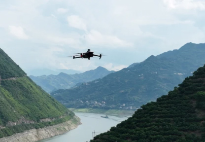
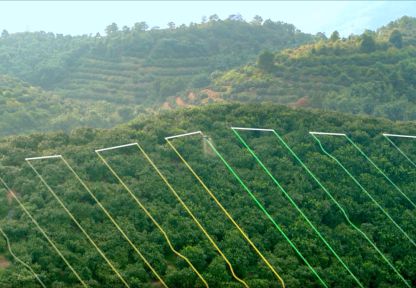
Effective aerial surveying needs to see the invisible. That's why Mavic 3 Multispectral has two forms of sight. It combines an RGB camera with a multispectral camera to scan and analyze crop growth with total clarity. Agricultural production management requires precision and data, and Mavic 3M delivers both.
- Compatto e portatile: Pieghevole per una facile conservazione
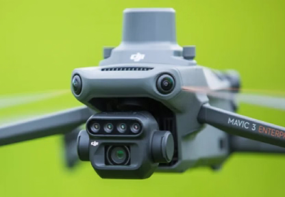
- Fotocamera multispettrale: 4 × 5 MP, G/R/RE/NIR
- Fotocamera RGB: 20 MP, CMOS da 4/3, otturatore meccanico
- Stabile e sicuro: Aggiramento degli ostacoli omnidirezionale [1]
Distanza di trasmissione di 15 km - Posizionamento preciso: Posizionamento RTK millimetrico
Sincronizzazione temporale in microsecondi - Rilievi aerei efficienti: Fino a 2 km quadrati per volo
Per saperne di più: https://ag.dji.com/mavic-3-m
Here are some frequently asked questions
Better Energy Starts Here that is Powered by Advanced Solar Materials and with it’s Modern Tech
How long does it take to install solar panels?
We provide a wide range of green energy solutions, including solar panel installation, maintenance, and energy efficiency consultations tailored to your needs.
What services do you offer for businesses?
We provide a wide range of green energy solutions, including solar panel installation, maintenance, and energy efficiency consultations tailored to your needs.
Do you offer warranties on your products?
We provide a wide range of green energy solutions, including solar panel installation, maintenance, and energy efficiency consultations tailored to your needs.
Can small businesses benefit from your services?
We provide a wide range of green energy solutions, including solar panel installation, maintenance, and energy efficiency consultations tailored to your needs.
What kind of maintenance is required for solar systems?
We provide a wide range of green energy solutions, including solar panel installation, maintenance, and energy efficiency consultations tailored to your needs.